Route 66 Trip Planning: Your Complete Guide to the Mother Road
Planning a Route 66 road trip is one of the most rewarding things you can do as a traveler — and one of the most easily overwhelmed. The highway runs 2,448 miles across eight states, from the Begin sign at Adams and Michigan in downtown Chicago to the End of the Trail at the Santa Monica Pier. It crosses four climate zones, hundreds of small towns, and more than a century of American history. The number of decisions involved — when to go, which direction to drive, how many days to take, what to pack, how to navigate the historic alignment, where to stay — can feel overwhelming before the first mile is driven.
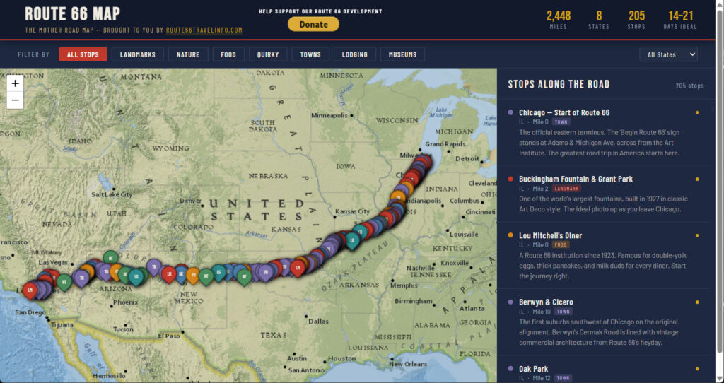
Route 66 Map
Use the Interactive Route 66 Map and this website to learn more about the places to see on Route 66.
Then, once you’ve got a good idea about what you’d like to see, go to the Personalized Route 66 Itinerary Builder and layout your trip.

This page is your starting point. Everything you need to plan a Route 66 trip — whether you have two weeks or two months, whether you’re traveling solo or with a family, on a motorcycle or in an RV, on a tight budget or ready to spend on the iconic experiences — is organized here into a complete planning system. Eight dedicated planning guides cover every major decision in detail. A Quick-Start answers table gives you the key answers immediately. And the Interactive Route 66 Trip Planner lets you check off the stops you want to visit, answer a few questions about your trip, and receive a personalized day-by-day itinerary generated specifically for you.
Route 66 rewards preparation without punishing spontaneity. The travelers who have the best trips are the ones who understood the road before they drove it — who knew where the dead zones were, which motels to book months in advance, why the morning hours matter in the desert, and how to read the brown historic signs that keep you on the original alignment instead of the interstate. This planning guide gives you all of that. The road does the rest.
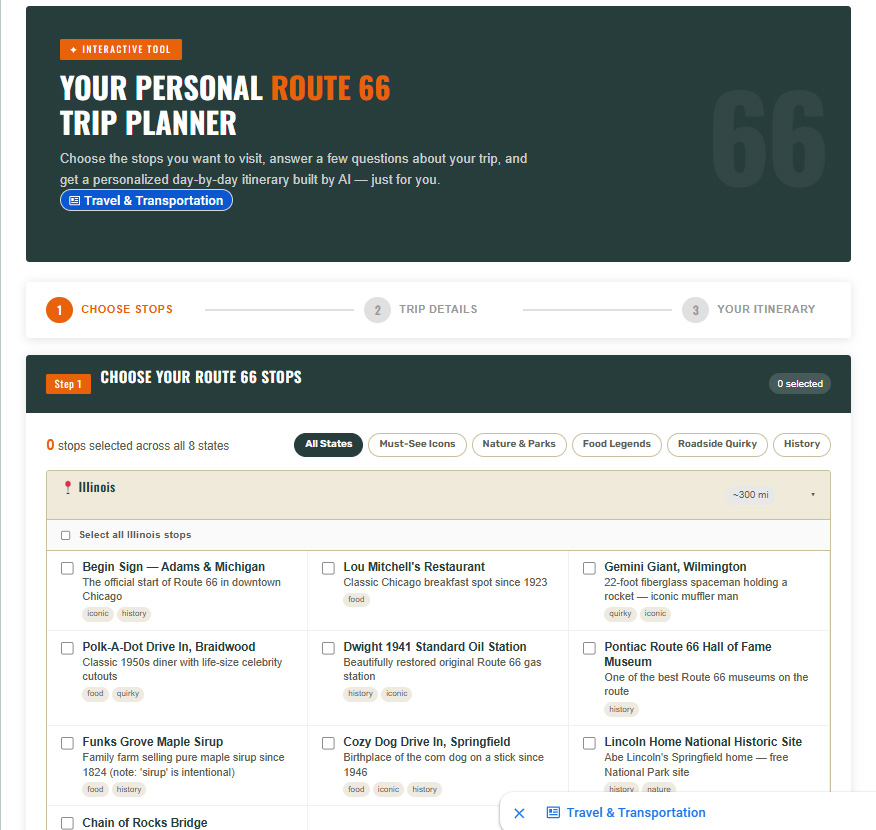
Start Here: The Route 66 personalized Itinerary Builder

Before diving into the planning guides, consider starting with our AI-powered Interactive Rote 66 Itinerary Builder — the fastest way to get a personalized Route 66 itinerary based on exactly what you want to see.
✦ INTERACTIVE PERSONALIZED ITINERARY BUILDER ✦
Choose the Route 66 stops you want to visit from our complete checklist of 140 attractions across all 8 states. Answer a few questions about your trip — how many days you have, which direction you’re driving, your travel style, and any special interests. Our AI planner builds a personalized day-by-day itinerary that fits your stops into your schedule, adds recommendations that match your interests, and flags the things you need to book in advance.
→ Launch the Route 66 Personalized Itinerary Builder
Quick-Start Answers: The Most Common Route 66 Planning Questions
If you’re just getting started and need the key answers before diving into the full planning guides, this table covers the most important decisions — with the short answer and the nuance that matters.
| The Question | The Short Answer | The Nuance |
| How long will my trip take? | 14 days minimum for full route satisfaction; 21 days is the ideal pace; partial routes possible in 5–7 days | 10 days if very experienced; most first-timers need 14–21 days; never rush Route 66 |
| Which direction should I drive? | East to West (Chicago → Santa Monica) — traditional direction, guidebooks written for it, the Pacific Ocean payoff | West to East works for West Coast residents or repeat drivers wanting a fresh perspective |
| What’s the best time of year? | Fall (Sept–Nov) is the overall best — ideal temperatures, lower crowds, golden light for photography | Spring is second-best; summer is most popular but requires desert heat preparation; winter suits AZ and CA only |
| How much will it cost? | Budget traveler: $1,400–$1,900 for 14 days solo; Mid-range couple: $3,400–$5,000 for 14 days | Fuel is $250–$540 depending on vehicle and direction; historic motels $95–$185/night; book early |
| What do I need to bring? | EZ66 Guide, offline maps, 4+ gallons water for desert sections, vehicle coolant check, spare tire confirmed | Full packing checklist and vehicle prep guide available — read it before departure, not after |
| How do I stay on the historic road? | EZ66 Guide + offline maps + brown Historic Route 66 signs — GPS alone will put you on the interstate | New Mexico and Arizona have the worst cell coverage — download offline maps before entering both states |
| Is Route 66 good for families? | Excellent — Cadillac Ranch, Blue Whale, Wigwam Motel, Petrified Forest Junior Rangers, Pixar Cars connection | Plan to the youngest child’s pace; desert heat safety is critical; the Centennial 2026 is ideal family timing |
| Is Route 66 good for motorcyclists? | One of the greatest motorcycle roads in the world — Oatman switchbacks, Ozark two-lanes, Seligman corridor | Full gear mandatory in the desert; carry satellite communicator; ride desert sections before 10 AM in summer |
The Complete Route 66 Trip Planning Guide Library
Each of the eight guides below covers one major planning decision in full depth — with custom tables, state-by-state breakdowns, honest cost estimates, and the specific practical details that make the difference between a trip that goes smoothly and one that doesn’t. Read the guides that apply to your specific situation, in any order. Every guide also links back to this page and cross-references the others where relevant.
| # | Planning Guide | Read Time | What It Covers |
| 01 | Best Time of Year to Drive Route 66 Timing · Weather · Crowds · Budget | 15 min read | Season-by-season weather, crowd levels, and budget breakdown for all 8 states. Spring vs. summer vs. fall vs. winter — which is right for your trip? Includes the Seasons at a Glance comparison table and state-by-state weather notes. |
| 02 | How Long Does It Take to Drive Route 66? Duration · Mileage · Itinerary · Pace | 12 min read | Full route vs. partial options with realistic daily mileage guidance. 10-day minimum through 4-week deep dive, plus partial route itineraries for every schedule. Includes state-by-state miles, minimum days, and what makes you linger. |
| 03 | East to West or West to East? Direction · Chicago · Santa Monica · Logistics | 10 min read | The complete direction decision guide — photography light, iconic finishes, logistics, guidebook support, and narrative arc compared side by side. Includes a 12-factor head-to-head table and a traveler profile decision guide. |
| 04 | Budgeting for a Route 66 Road Trip Budget · Fuel · Lodging · Food · Cost | 14 min read | Honest fuel, lodging, and food cost estimates at Budget, Mid-Range, and Splurge tiers. Includes the complete Trip Budget Estimator table, state-by-state fuel price guide with fill-up strategy, and the top historic motels worth the price. |
| 05 | Route 66 Packing List & Vehicle Prep Checklist Packing · Vehicle · Safety · Desert Prep | 16 min read | The complete printable pre-trip checklist covering vehicle inspection, safety gear, desert water requirements, navigation tools, documents, clothing, and photography equipment. Priority-rated vehicle inspection table with desert-specific guidance. |
| 06 | Navigating Route 66: Maps, Apps & Signs Navigation · Maps · Apps · Signs · GPS | 13 min read | How to stay on the historic alignment using the EZ66 Guide, offline maps, and the road sign system. Includes cell service dead zone guide by state, the 5 most commonly missed sections, and the complete state-by-state alignment navigation table. |
| 07 | Family-Friendly Planning Tips Family · Kids · Safety · Cars Movie | 15 min read | Age-by-age planning strategies for every stage from infants to teenagers, the top 12 family stops on the route, desert safety with children, the Pixar Cars connection, car entertainment strategies, and family budget tips. |
| 08 | Solo Traveler & Motorcycle Guide Solo · Motorcycle · Safety · Gear · Community | 17 min read | Complete guidance for solo drivers and motorcyclists covering safety planning, the best motorcycle sections rated by road type, gear recommendations with Route 66-specific notes, daily riding rhythm, and the motorcycle community culture. |
The Five Most Important Route 66 Planning Decisions
Of all the decisions involved in planning a Route 66 trip, five have the greatest impact on the quality of the experience. Get these five right and everything else falls into place.
1. When to Go
The single most impactful decision in Route 66 planning is timing. The highway crosses eight states and four climate zones, and the same road that is ideal in October is dangerous in July in the desert and miserable in January in Illinois. The fall season — September through November — is the overall best for most drivers: comfortable temperatures across all eight states, lower crowds than summer, and the golden light that makes Route 66 photography extraordinary. Spring is second-best. Summer is the most popular and the most demanding. Winter suits only the western states.
Full breakdown: Best Time of Year to Drive Route 66
2. How Long to Take
Route 66 consistently punishes travelers who underestimate the time required. The minimum for a genuinely satisfying full-route trip is 14 days, and 21 days is where the trip stops feeling rushed and starts feeling like the experience it was meant to be. The most common mistake is planning adult-pace mileage (200+ miles per day) and discovering on day three that the best things on Route 66 happen at stops you drove past. Budget more time than you think you need. The road will fill it.
Full breakdown: How Long Does It Take to Drive Route 66?
3. Book the Right Motels Before You Leave
The most iconic Route 66 motels — the Blue Swallow in Tucumcari, the Wigwam Motel in San Bernardino and Holbrook, the Munger Moss in Lebanon, Missouri, the El Rancho Hotel in Gallup — book out weeks and months in advance during peak season. In the Centennial year of 2026, they will be booked faster than ever. The travelers who get these rooms are the ones who planned ahead. Book the motels that matter to you before you book anything else. Walk-in availability at the iconic properties in peak season is essentially zero.
Lodging cost guide: Budgeting for a Route 66 Road Trip
4. Navigate the Historic Alignment — Not the Interstate
Route 66 is not a single highway. It is a series of historic alignments — county roads, frontage roads, and state highways — that run alongside or beneath Interstate 40 for most of its length. GPS navigation defaults to the interstate every time. The travelers who stay on the historic alignment are the ones who carry the EZ66 Guide, download offline maps before entering New Mexico and Arizona, and follow the brown Historic Route 66 signs. The two-lane historic road is the entire point of the trip. Getting off the interstate is not optional — it is the trip.
Full navigation guide: Navigating Route 66: Maps, Apps & Signs
5. Prepare Your Vehicle for the Desert
The Arizona and California desert sections of Route 66 — where temperatures regularly exceed 110–115°F in summer and where services can be 30–50 miles apart — are genuinely unforgiving of vehicle problems. A cooling system failure that would be an inconvenience in Illinois is an emergency in the Mojave. Have your cooling system pressure-tested, your tires inspected, and your battery load-tested before departure. Carry a minimum of four gallons of water. Carry a satellite communicator if you are traveling solo. Prepare as if the desert were serious — because it is.
Complete vehicle prep and packing guide: Route 66 Packing List & Vehicle Prep Checklist
Route 66 State by State: What Each State Offers
Route 66 passes through eight states, and each one has a distinct character, climate, and set of experiences. Here is the essential briefing on each — what makes it worth slowing down for, and what every traveler should know before arriving.
Illinois (~300 miles)
Route 66 begins at Adams Street and Michigan Avenue in downtown Chicago and runs 300 miles southwest to the Missouri border. Illinois offers the strongest contrast of the entire route — the urban energy of Chicago followed almost immediately by the small-town corridor through Joliet, Wilmington (the Gemini Giant), Dwight, Pontiac, and Springfield. The Lincoln sites in Springfield, the Cozy Dog Drive In (birthplace of the corn dog), and the Chain of Rocks Bridge are the headline stops. Illinois Route 66 is well-marked, well-documented, and an excellent introduction to the road.
Missouri (~317 miles)
Missouri offers the most navigationally complex section of Route 66 — multiple historical alignments through the Ozarks require the EZ66 guide — and some of the most rewarding two-lane driving on the entire route. The Chain of Rocks Bridge over the Mississippi, Meramec Caverns, the Cuba murals, the Munger Moss Motel in Lebanon, and the Ozark two-lane alignments through the forested hills are Missouri’s signature. Budget two full days minimum.
Kansas (~13 miles)
Kansas is the shortest state on Route 66 at just 13.2 miles — but it is not skippable. The Hudson tow truck that inspired Mater in Pixar’s Cars (at Cars on the Route in Galena), the Rainbow Curve Bridge, and the Eisler Brothers Old Riverton Store are genuine Route 66 treasures in miniature. Half a day covers Kansas thoroughly.
Oklahoma (~400 miles)
Oklahoma has more original, driveable Route 66 alignment than any other state — approximately 400 miles — and is consistently the state where itineraries fall furthest behind schedule. The Blue Whale of Catoosa, Pops 66 in Arcadia, the National Route 66 Museum in Elk City, Totem Pole Park, and the dense concentration of authentic Route 66 commercial culture make Oklahoma a two-day minimum state for any serious Route 66 traveler.
Texas (~178 miles)
Texas means the Panhandle — flat, exposed, magnificently big-sky driving. Cadillac Ranch outside Amarillo is the most participatory art installation on Route 66 (bring spray paint). The U-Drop Inn in Shamrock is the finest Art Deco building on the entire route. The Midpoint Café in Adrian marks the exact geographic center of Route 66. The Texas section is shorter than most expect but delivers some of the most iconic moments on the highway.
New Mexico (~487 miles)
New Mexico is the longest state on Route 66 by mileage and the one with the most dramatic cell service dead zones — download offline maps before entering. The Tucumcari neon strip after dark, the Blue Swallow Motel, Old Town Albuquerque, the historic Central Avenue alignment through the city, and the El Rancho Hotel in Gallup are New Mexico’s crown jewels. The high desert landscape is extraordinary and unlike anything in the other seven states.
Arizona (~401 miles)
Arizona is where Route 66 reaches its most dramatic and most iconic. The Petrified Forest National Park and Painted Desert, Standin’ on the Corner in Winslow, Flagstaff’s mountain character, the preserved ghost-town atmosphere of Seligman and Hackberry, and the switchback mountain road over Sitgreaves Pass to Oatman make Arizona the richest single state for Route 66 experiences. Budget two full days minimum — three if adding a Grand Canyon detour from Williams.
California (~315 miles)
California begins at the Colorado River crossing at Needles and ends at the Santa Monica Pier. The Mojave section — remote, extreme, and hauntingly beautiful — includes Roy’s Motel and Café in Amboy, one of the most photographed buildings in the American West. The Wigwam Motel in San Bernardino, the Inland Empire corridor, and the final approach through Pasadena and the Los Angeles basin conclude at the End of the Trail sign on the Santa Monica Pier. Budget extra time for Los Angeles traffic on the final approach.
Planning for the Route 66 Centennial 2026
On November 11, 2026, Route 66 celebrates its 100th anniversary — the single most significant milestone in the highway’s modern history. The highway was commissioned on that date in 1926, and the Centennial year will generate the largest wave of Route 66 tourism and events in the highway’s history. Events, celebrations, car shows, organized group drives, and community gatherings are being planned across all eight states throughout 2026, with the largest concentration expected around the November anniversary.
If you are planning a Route 66 trip in 2026:
- Book all accommodation before January 2026. Historic motels will be fully booked for peak season months before the dates arrive. This is not an exaggeration — the Centennial year will be unlike any previous year on the highway.
- The November 2026 anniversary period will have the highest concentration of organized events. A departure from Chicago in mid-October arriving in Santa Monica in early November puts you on the road during the heart of Centennial celebrations.
- Organized Centennial group drives are expected from both Chicago and Santa Monica — check the Route 66 state associations for organized ride and drive schedules.
- The Interactive Trip Planner can be used to build a Centennial itinerary — just select your desired stops, enter 2026 dates, and note in the special instructions field that you want to incorporate Centennial events.
Full Centennial event calendar and planning resources: Route 66 Centennial 2026
Route 66 State Associations: Your Local Planning Resource
The eight Route 66 state associations are the most underused planning resource available to Route 66 travelers. These organizations — staffed by people who live on and love the route — maintain current information on road conditions, operating businesses, seasonal closures, local events, and the specific historic alignments and attractions that do not appear in any published guidebook. Connecting with the state association before driving each state consistently produces better trips.
The Route 66 State Associations page provides contact information, membership details, and event calendars for all eight state associations — Illinois, Missouri, Kansas, Oklahoma, Texas, New Mexico, Arizona, and California.
Complete Route 66 Trip Planning Resources
Interactive Route 66 Trip Planner — Choose your stops, enter your trip details, and receive a personalized AI-generated day-by-day itinerary.
Best Time of Year to Drive Route 66 — Season-by-season weather, crowd levels, and budget guide.
How Long Does It Take to Drive Route 66? — Full route and partial route time and mileage guide.
East to West or West to East? — The complete direction decision guide.
Budgeting for a Route 66 Road Trip — Fuel, lodging, and food cost estimates at every spending level.
Route 66 Packing List & Vehicle Prep Checklist — Complete pre-trip preparation guide.
Navigating Route 66: Maps, Apps & Signs — How to stay on the historic alignment.
Family-Friendly Planning Tips — Age-by-age planning for families with children.
Solo Traveler & Motorcycle Guide — Complete guidance for solo drivers and motorcyclists.
Route 66 Complete Travel Guide — The full overview of all 2,448 miles: history, alignments, and state-by-state planning.
Route 66 in Illinois — Chicago to the Missouri border.
Route 66 in Missouri — The Ozarks and the River.
Route 66 in Kansas — 13 miles of essential Route 66.
Route 66 in Oklahoma — The most original alignment of any state.
Route 66 in Texas — Cadillac Ranch, the Panhandle, and the midpoint.
Route 66 in New Mexico — Neon, high desert, and Albuquerque’s Central Avenue.
Route 66 in Arizona — The Painted Desert, Petrified Forest, and Oatman.
Route 66 in California — The Mojave and the End of the Trail.
Petrified Forest National Park — The park that Route 66 runs through.
The Painted Desert — Banded desert badlands at their most extraordinary.
Route 66 Centennial 2026 — The 100th anniversary: events, planning, and why 2026 matters.
Route 66 State Associations — Your local planning resource in all eight states.
Route 66 Trip Planning Articles
Check the most recent articles about Route 66 Trip Planning